| Polish Hill | Upper Allegheny | Lower Allegheny | Mt Washington | Mon River | Map and Directions | City Ride Overview |
Blue-green line is route of ride. Written
directions below. Click on ![]() for panoramas.
for panoramas.
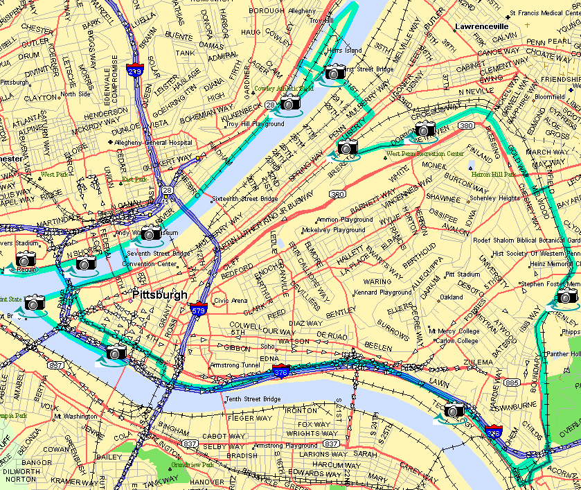
One of our favorite in-town Sunday rides is a loop from Oakland to the North Side and Downtown, covering about 15-20 miles. It’s a Sunday morning ride because of the 8-block stretch on Commonwealth Pl and the Blvd of the Allies in downtown, which has too much traffic for our taste the rest of the week. About half of this trip is on trails, about half on low-traffic neighborhood streets, and about 1 mile on busy city streets.
Begin at your favorite location in Oakland and work your way over to head north on Neville Ave. go north on Neville to Centre. Turn left on Centre and then right at the next light on Melwood Av. Go north on Melwood, crossing Centre Av and Baum Blvd. Just past Pittsburgh Filmmakers, turn left for one block up a short steep hill, then right on Gold Way. Follow Gold Way [[pan]] under the Bloomfield Bridge; it turns into Melwood somewhere along here. At Herron Av, turn right, then immediately left on Dobson St. Follow Dobson until it ends at Immaculate Heart of Mary Church. Turn right on Brereton and follow it until you can turn right to cross the busway [[pan]]. Cross the busway, emerging on 28th St at Penn Av. Cross Penn Av and turn right at the next alley (Spring Way). Follow the alley to 31st St and turn left onto the 31st St Bridge [[pan]]. At the stoplight just before the end of the bridge, turn left on the ramp down to River Av. Take an immediate left onto the 30th St bridge, which crosses to Washington Landing. When you come off the bridge, you can go left past Three Rivers Rowing to the upstream end of the island and come back down the trail alongside the main channel of the river. Alternatively, turn right through the townhouses, looking for a way to get onto the trail. At the downstream end of the island [[pan]], take the bike bridge across the back channel and go down the switchback ramp.
At the end of the ramp, join the North Shore trail, between the RR tracks and the river. Follow the trail under Veterans Bridge and the RR bridge, [[pan]] past Alcoa headquarters, to PNC baseball stadium [[pan]]. During construction of the football stadium in 2001, the trail is interrupted here. When the trail reopens, you'll be able to continue to a ramp to the Ft Duquesne Bridge and thence to Point State Park. You'll also be able to continue past the Ft Duquesne Bridge to the Carnegie Science Center, the West End Bridge, and eventually the county line. For now, though, backtrack on the trail from PNC Stadium to the 7th St Bridge. Cross the bridge and take the ramp down to the park at water level. Go downstream and cross under the Ft Duquesne Bridge.
One alternative here is turn left up the ramp to the end of the Ft Duquesne pedestrian ramp and follow the marked bike path through Point State Park, emerging on Commonwealth Pl in front of the Hilton Hotel. At the Hilton, turn right and follow Commonwealth Pl to Blvd of the Allies. Turn left on the Boulevard and go about six blocks to Grant St.
A second alternative after crossing under the Ft Duquesne Bridge is to continue around Point State Park at river level [[pan]]. Note that bikes are permitted only on these two routes through Point Park. Exit the park staying as close to the Monongahela River as possible and follow the sidewalk down to the Mon Wharf parking area [[pan]]. Leave the parking wharf by the car exit, which takes you to the corner of Ft Pitt Blvd and Smithfield St. One-way streets work against you here. Either walk your bike two blocks down Smithfield to the Blvd of the Allies or go left (only legal way) on Ft Pitt Blvd until you can turn right to the Blvd. However you get to the Blvd, turn right and go to Grant St.
In either case, cross Grant St, jogging right on Court St (which runs adjacent to the Blvd, but stays level when the Blvd climbs). Take the first right (on Ross St), then the next left (on 1st Av), then the next right (into the parking lot). Go across the parking lot, then left toward the jail.
Enter the Eliza Furnace Trail to the right of the driveway that leads past the jail. Follow the Eliza Furnace Trail [[pan]] to its end in the Swinburne St parking lot. Leave the parking lot via Swinburne St and turn left between the retaining wall and the Jersey barrier that separates the bike path from 2nd Av. Follow the protected bike path left under the railroad tracks, under the highway, and up through Junction Hollow (popularly called Panther Hollow). When this trail ends, follow the road to get back onto Neville St in Oakland. If you take a sharp right just after crossing the RR tracks at grade, you can work your way up to the Carnegie Mellon University campus [[pan]] and Schenley Park.
Up to Mary Shaw Home
Electronic mail: mary [at] shaw [dot] org
Sorry, but I can't put a mailto link in here because the
spammers will harvest it. To contact me, edit the pieces together
in the obvious way.
Snail mail: Shaw-Weil Associates, 414 South Craig St PMB 307, Pittsburgh PA 15213
Copyright © 2000 by Mary Shaw. Use of any portion of this site to generate spam or other mass communication is forbidden. Last revised: August 06, 2001.